
Destination
Marmaraereğlisi Feneri
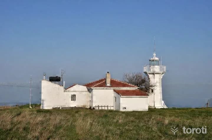
The lighthouse, built on the cape at the southern end of Ereğli bay in 01.01.1861, operates at a height of 52 meters above sea level, with a tower height of 26 meters. The light of the lighthouse, rising on a metal tower, has the power to be seen from a distance of 16 miles. The rotating lighthouse system is electric - battery-powered, and the bulb type is 50 W.
Marmaraereğlisi Feneri and 6 places around it
Free · no sign-up needed
Highlights
- Local culture
Suggested visit:45 minutes
The lighthouse, established on 01.01.1861 on the cape at the southern end of Ereğli bay, operates at a height of 52 meters above sea level, with a tower height of 26 meters. The light of the lighthouse, rising on a metal tower, has a visibility range of 16 miles. The rotating lighthouse system is electric - battery-powered, and the bulb type is 50 W. Reached in a short time by a narrow dirt road from inside Marmara Ereğlisi, you can walk around the empty area within the wire fence surrounding the lighthouse and the keeper’s house and go to both sides of the cape.
Those walking around from the sea side encounter an ancient cave remaining from the ancient city of Perinthos. Those walking around from the back side of the lighthouse can see the fishermen’s shelter and Marmara Ereğlisi from above.
The lighthouse and the keeper building are under protection by the General Directorate of Coastal Safety as national heritage.
Source:https://www.kiyiemniyeti.gov.tr/yer-detay/204/MARMARA-EREGLISI-FENERI#//kiyiemniyeti.gov.tr/Data/1/Files/Place/Images/Cq/cx/IP/Zj/Original/120_fdc7cd21-29c8-462d-b564-0ce42a2400d3.png Address: Mustafa Kemal Paşa Mah./Marmaraereğlisi/TEKİRDAĞ
Last updated: 21 October 2026
Location and surroundings
Marmaraereğlisi Feneri sits within Marmaraereğlisi, Tekirdağ. The toroti catalogue holds 97 described stops across Tekirdağ, 5 of them in Marmaraereğlisi.
The nearest stop is Cedid Ali Paşa Camii, 570 m to the west. Another 6 catalogued points lie within a 30 km radius.
The Istanbul – Canakkale route passes 1.2 km away, so this works as a stop along the drive.
See Marmaraereğlisi Feneri and its surroundings in one plan
- Order your stops on the map and spread them across days
- See driving and visiting time at a glance
- Get places around it suggested automatically
- Free — no sign-up needed to start
Other places nearby
Routes that pass close by
Frequently asked
- What is Marmaraereğlisi Feneri?
- The lighthouse, built on the cape at the southern end of Ereğli bay in 01.01.1861, operates at a height of 52 meters above sea level, with a tower height of 26 meters. The light of the lighthouse, rising on a metal tower, has the power to be seen from a distance of 16 miles. The rotating lighthouse system is electric - battery-powered, and the bulb type is 50 W.
- Where is Marmaraereğlisi Feneri?
- Marmaraereğlisi Feneri is in Marmaraereğlisi, Tekirdağ.
- How long does it take to visit Marmaraereğlisi Feneri?
- The suggested visit time for Marmaraereğlisi Feneri is about 45 minutes.
- What else is there to see near Marmaraereğlisi Feneri?
- toroti’s catalogue holds other destinations within 30 km of Marmaraereğlisi Feneri; the closest are Cedid Ali Paşa Camii, Marmaraereğlisi, Perinthos Antik Kenti.
- Is Marmaraereğlisi Feneri on the way anywhere, and which route?
- Marmaraereğlisi Feneri lies 1.2 km from the Istanbul – Canakkale route, close enough to add to that drive with a short detour.