
Destination
Melikler Yaylası
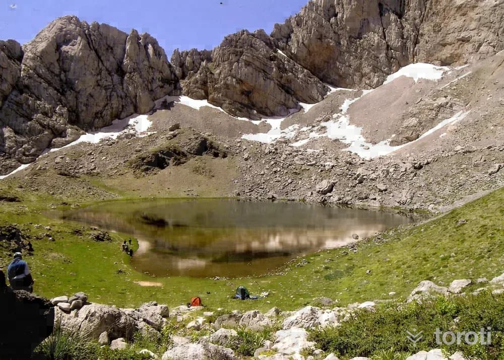
Melikler Plateau is a scenic plateau located at the foothills of Dedegöl Mountain, known for its natural beauty. It is also recognized for the Dedegöl Mountaineering Festival held every May.
Melikler Yaylası and 6 places around it
Free · no sign-up needed
Highlights
- Hiking
- Photography
Good for
- Nature lovers
- Families
Suggested visit:120 minutes
Located within the borders of Yenişarbademli District, on the foothills of Dedegöl Dağı, Melikler Yaylası is 15 kilometers from Yenişarbademli District. The plateau area is reached by proceeding about 2 kilometers on the stabilized road branching south from the “Vali Çeşmesi” locality on the Yenişarbademli-Aksu highway. There is a fountain in the plateau area that can be used as drinking water. However, since the section to the east and southeast of the fountain and the stabilized road lies within the borders of Kızıldağ Milli Parkı, camping is not possible in this area.
Melikler Yaylası Tourism Area:
The camping area is surrounded by pine trees, on a flat area offering an excellent view of Dedegöl Dağı, and is at an altitude of 1735. In addition, the Dedegöl Mountaineering Festival, organized every year in May on this plateau by Eğirdir Turizm Tanıtma ve Doğa Sporları Kulübü (ETUDOSD), stands out as an important activity at the national level. The area is within the responsibility zone of Isparta Orman Bölge Müdürlüğü. Activities can be carried out by taking the security measures deemed appropriate by the Orman Bölge Müdürlüğü. The eastern part of the area is the border of Kızıldağ Milli Park.
Alternative Activities :
Walk from the plateau area to Pınargözü Mağarası. Walk from the plateau area to Yaka Kanyonu. Climb Dedegöl Dağı
Yenişarbademli Melikler Yaylası- Pınargözü Mağarası Walking Route:
Melikler Yaylası, located within the borders of Yenişarbademli District on the foothills of Dedegöl Dağı, is reached by proceeding about 2 kilometers on the stabilized road branching south from the “Vali Çeşmesi” locality on the Yenişarbademli-Aksu highway. After walking approximately 350 metres on the road descending south from the plateau area with a view of Dedegöl Dağı, turn left (east) at the fountain encountered. After this point, there is no road junction on the stabilized road and it leads directly to Pınargözü Mesire Alanı and Pınargözü Mağarası. After the fountain, when proceeding about 500 metres on the road, Cukka Pınarı Çeşmesi is encountered. After proceeding 20 thousand metres on the winding road through the forest formed by centuries-old pine trees, visitors are greeted by Beyçam Anıt Ağacı. This black pine tree, more than 700 years old, has a diameter of 155 cm, a circumference of 465 cm and a height of 28,5 metres. Beyçam Anıt Ağacı also indicates that the route is about to end. After proceeding about 200 metres from this tree, Pınargözü Mesire Alanı and Pınargözü Mağarası are reached. The recreation area can be used for daily activities, and one can go as far as the entrance of Pınargözü Mağarası and take photographs. The spring that gives the cave its name also takes its source from the depths of this cave
Melikler Yaylası Photography Spot:
The pine trees surrounding the area and the view of Dedegöl Dağı can be the subject of beautiful photographs. Pınargözü Mağarası, reached with a 2 km walk, and the stream flowing between the rocks are suitable spots both for taking photographs and for resting.
In addition, the Dedegöl Mountaineering Festival, organized every year in May on this plateau by Eğirdir Turizm Tanıtma ve Doğa Sporları Kulübü (ETUDOSD), stands out as an important activity at the national level. The area is within the responsibility zone of Isparta Orman Bölge Müdürlüğü. Activities can be carried out by taking the security measures deemed appropriate by the Orman Bölge Müdürlüğü. The eastern part of the area is the border of Kızıldağ Milli Park.
Alternative Activities:
Walk from the plateau area to Pınargözü Mağarası. Walk from the plateau area to Yaka Kanyonu. Climb Dedegöl Dağı.
Source: Isparta İl Kültür ve Turizm Müdürlüğü
Places to Visit in Isparta Address: Dedegöl Dağı, Yenişarbademli/ Isparta
Last updated: 16 October 2026
Location and surroundings
Melikler Yaylası sits within Yenişarbademli, Isparta. The toroti catalogue holds 143 described stops across Isparta, 5 of them in Yenişarbademli.
The nearest stop is Melikler- Pinargözü Yürüyüş Parkuru, 1.8 km to the north. Another 6 catalogued points lie within a 30 km radius.
See Melikler Yaylası and its surroundings in one plan
- Order your stops on the map and spread them across days
- See driving and visiting time at a glance
- Get places around it suggested automatically
- Free — no sign-up needed to start
Other places nearby
Frequently asked
- What is Melikler Yaylası?
- Melikler Plateau is a scenic plateau located at the foothills of Dedegöl Mountain, known for its natural beauty. It is also recognized for the Dedegöl Mountaineering Festival held every May.
- Where is Melikler Yaylası?
- Melikler Yaylası is in Yenişarbademli, Isparta.
- How long does it take to visit Melikler Yaylası?
- The suggested visit time for Melikler Yaylası is about 120 minutes.
- What else is there to see near Melikler Yaylası?
- toroti’s catalogue holds other destinations within 30 km of Melikler Yaylası; the closest are Melikler- Pinargözü Yürüyüş Parkuru, Yaka Kanyonu, Dedegöl Dağı.